Zurich printable map of top tourist attractions & city travel guide
Zurich city centre free travel guide - Top 10 must-see sights & best destinations - Zurich top tourist attractions map
Maps of best attractions in Zurich, Switzerland
Zurich maps will guide you to the best destinations in the city. Switzerland’s largest city is surely among the most beautiful in all of Europe, and even today, Zurich retains much of its charm. Situated on the northern shore of Lake Zurich in the heart of the country, the city is both large enough to offer all amenities to its visitors and small enough for you to discover on your own. The easiest way to get around the centre of Zurich is to walk, but to get from one side of the centre to the other, or to reach some of the outlying attractions, you'll need to use public transport. The best approach to sightseeing in Zurich is to use our maps to plan a combination of walking tours and trips on an excellent public transportation. Zurich top sights and key landmarks to visit are plotted on our detailed city plans. Public transportation points are also marked, and indicated by the symbols listed in the maps key. Armed with these maps, you should be able to find the accurate location of must-see places. Mapping out a trip to explore Zurich can be far from the usual. This page includes a range of maps and plans which will help you make the most of your visit to Zurich. If you are either a first-time tourist looking for the top 10 must-do sights or if you are returning to Zurich to discover something new - all you need to ensure an enjoyable trip is some advance planning. For some help in narrowing down the options, we present you with a range of high resolution maps which will help you find the detailed locations of the must-see sights - just click on a selected map to access a large version that can be downloaded and printed, or saved onto your mobile device. When in Zurich, you can also get free pocket-size maps of the city from the tourist information centre.
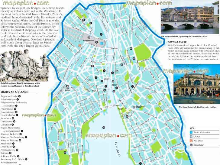
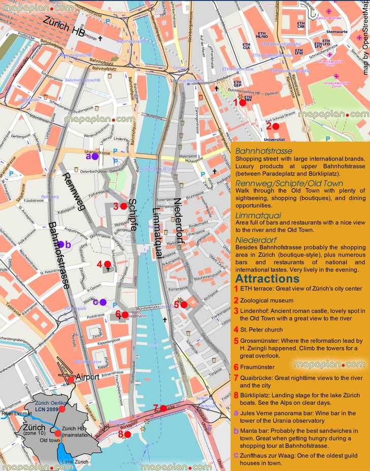
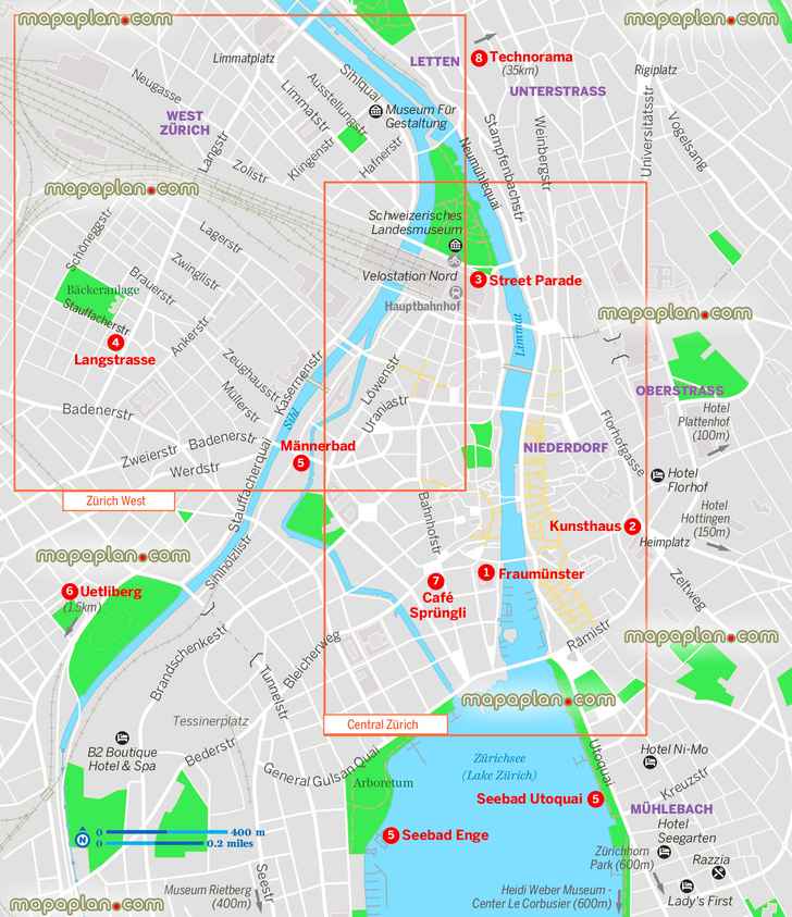
Zurich, Switzerland city center free printable interactive visitor's detailed guide map download for tourists showing public transport stations & tram stops plan, inner city old town, must-see sights, sightseeing places of interest, street names - Zurich top tourist attractions map
You can view, download or print a full, high resolution (detailed, large) version of this image by clicking on the plan itself
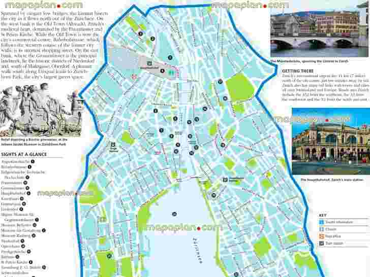
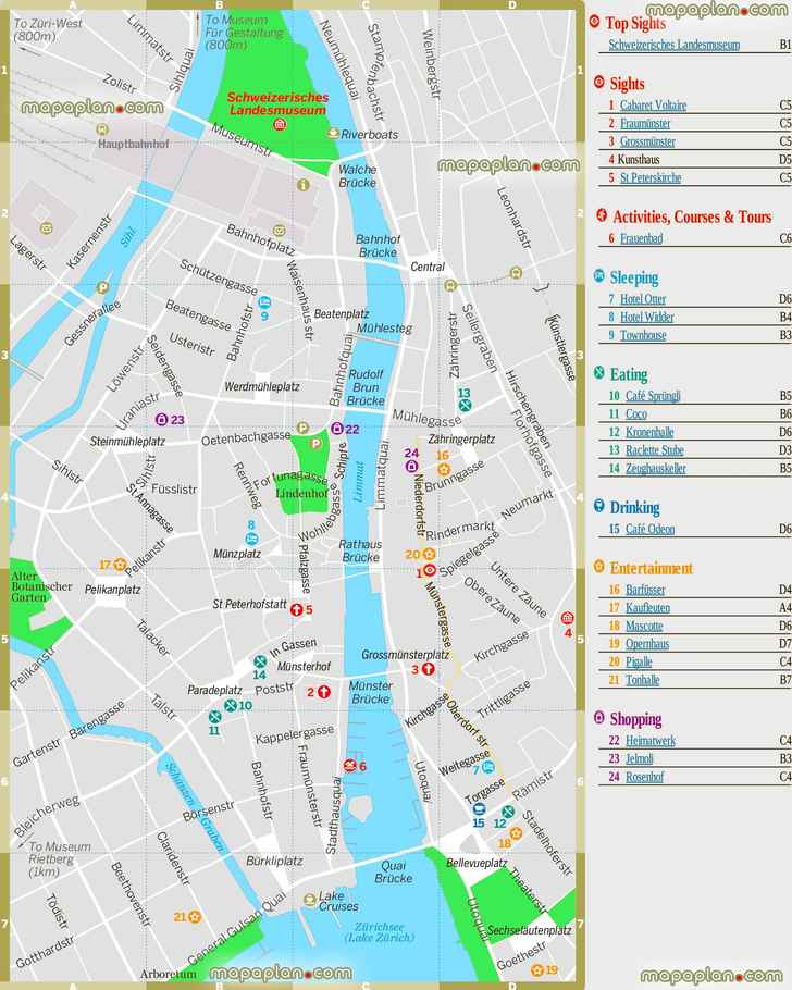
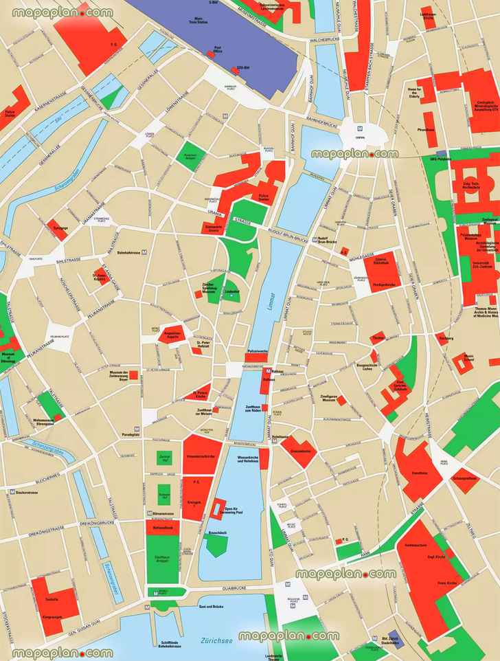
Central Zurich free to download offline popout English detailed walking itinerary guide map showing historical streets, virtual interactive 3d aerial satellite view, buildings, parks, best museums, art galleries, churches, shopping, tourist information, city centre top attractions - What to see, where to go, directions to interesting things to do - Zurich top tourist attractions map
You can view, download or print a full, high resolution (detailed, large) version of this image by clicking on the plan itself
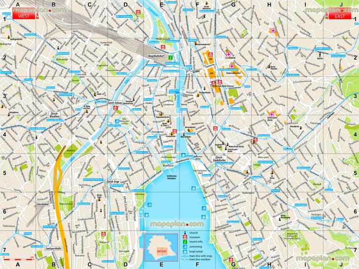
Zurich printable detailed interactive virtual city map (Stadt Karte Plan) - Interactive downloadable tourist guide for visitors in English showing must-see places - Travel layout plan free download - Offline map showing places to visit, must-see tourist attractions, famous destinations - Zurich top tourist attractions map
You can view, download or print a full, high resolution (detailed, large) version of this image by clicking on the plan itself
Map of Zurich tram & bus - Public transport network system showing stations, zones, routes, stops, updated transit diagram, train, Airport, ZVV & VBZ city tarifzones - Zurich top tourist attractions map
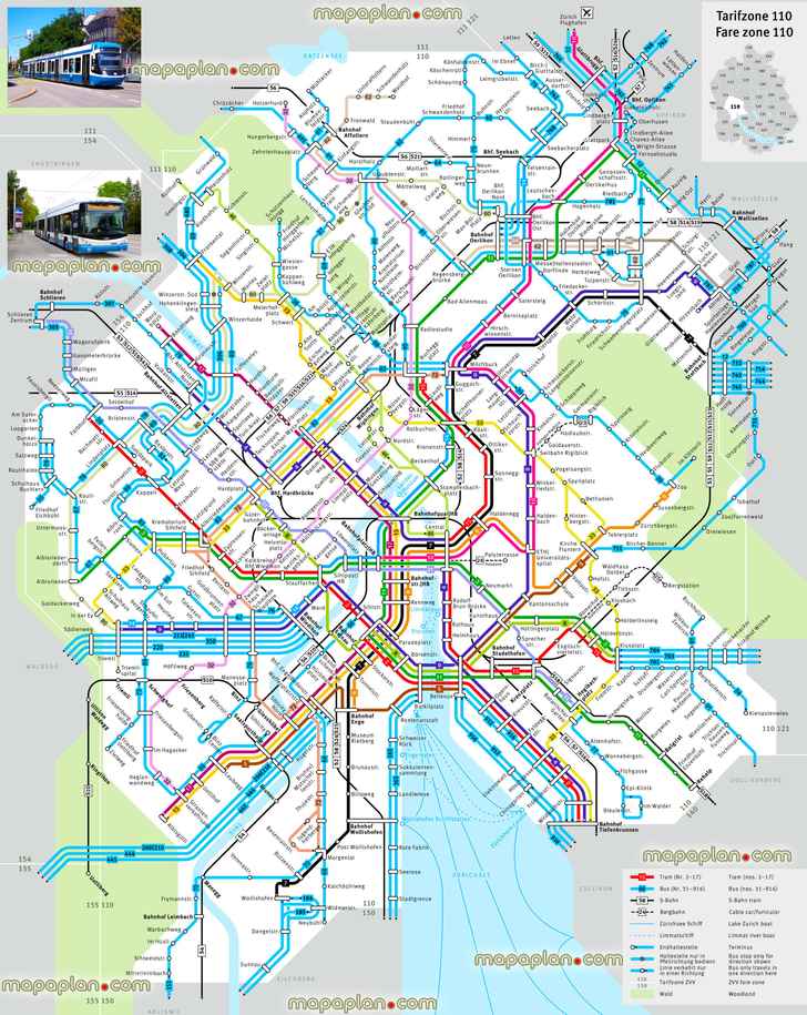
You can view, download or print a full, high resolution (detailed, large) version of this image by clicking on the plan itself
Zurich top tourist attractions map, central railway train station, tourist information centre free interactive printable detailed visitor's guide with street names, must-see destinations, hot spots worth visiting, best points of interest, Old Town (Altstadt), sights, hotels, restaurants, shopping - Zurich top tourist attractions map
You can view, download or print a full, high resolution (detailed, large) version of this image by clicking on the plan itself
Zurich top highlights guide map in English - High quality large scale printable sightseeing vector map with tram lines, stops, tourist information center, main train station (Hauptbahnhof) - Itinerary planner with navigation directions to best sights, landmarks, travel sites, points of interest - Zurich top tourist attractions map
You can view, download or print a full, high resolution (detailed, large) version of this image by clicking on the plan itself
Zurich map to download showing city sightseeing attractions for tourists - Visitor's 3d virtual interactive information plan with main points of interest, museums, landmarks - Overview of the city trip highlights including lake, Fraumunster, Kunsthaus, Limmat River - Zurich top tourist attractions map
You can view, download or print a full, high resolution (detailed, large) version of this image by clicking on the plan itself
Detailed street map of attractions near Zurich Lindenhof & Lake - Free to download & print travel guide of city center, locations of major attractions, tourist information office, great historic spots, best must-see sights, detailed view map showing orientation & navigation directions - Zurich top tourist attractions map
You can view, download or print a full, high resolution (detailed, large) version of this image by clicking on the plan itself
Zurich Bahnhofstrasse city centre visitor's walking map - Free to download interactive 1-day trip travel locations guide with directions to interesting sights around main railway station, simple & easy to navigate diagram showing holiday top points of interest - Central district neighourhood orientation - Zurich top tourist attractions map
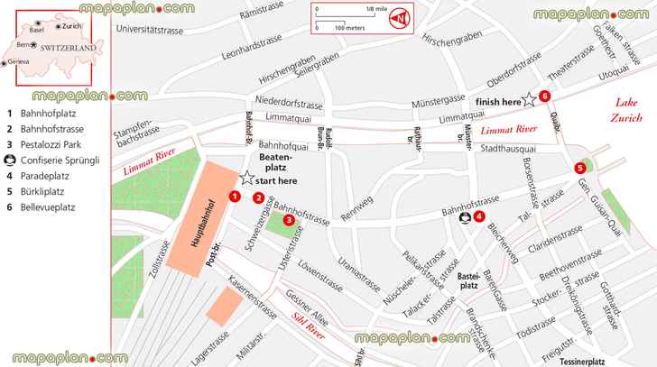
You can view, download or print a full, high resolution (detailed, large) version of this image by clicking on the plan itself
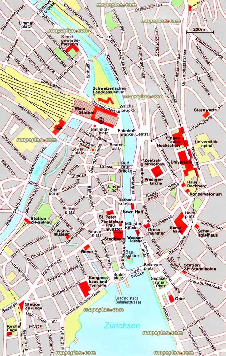
Central Zurich, Switzerland city centre detailed pop up map of must-see attractions, restaurants, hotel accommodation, interesting sites, must-do spots & landmarks - Free to download street & road names detailed hd map - Old Town (Altstadt), Lindenhof, Lindenplatz walking guide - Zurich top tourist attractions map
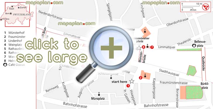
You can view, download or print a full, high resolution (detailed, large) version of this image by clicking on the plan itself
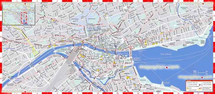
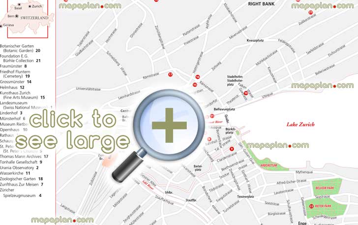
Greater Zurich metropolitan area free to download printable detailed guide map showing surrounding area attractions, road to airport, cities, main districts & neighbourhoods - Zurich top tourist attractions map
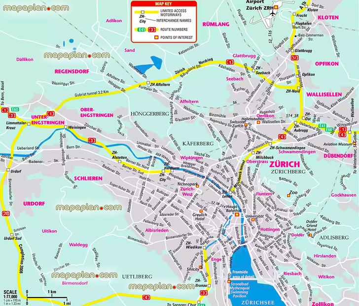
You can view, download or print a full, high resolution (detailed, large) version of this image by clicking on the plan itself
Hotels in Zurich & the map of Switzerland - City centre, old town square district area neighbourhood top attractions, Bahnhof train station - Historic centre printable sightseeing map with the list of accommodation - Zurich top tourist attractions map
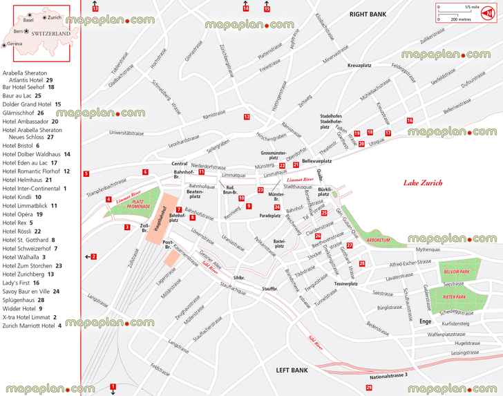
You can view, download or print a full, high resolution (detailed, large) version of this image by clicking on the plan itself
Restaurants in left & right Bank in Zurich city center - Zurich location on the map of Switzerland, Europe - Zurich top tourist attractions map
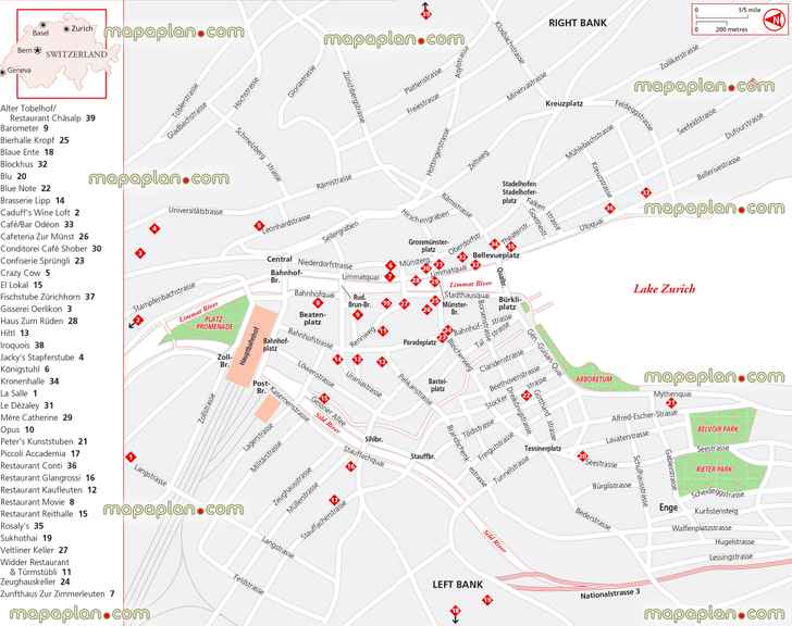
You can view, download or print a full, high resolution (detailed, large) version of this image by clicking on the plan itself
Zurich city center offline 3d interactive guide jpg map of main streets, tourist information centre, sightseeing downtown attractions, main train railway station - Interactive walking trip downloadable itinerary planner to print & guide map showing best destinations to visit - Central district area outline layout map of best locations - Zurich top tourist attractions map
You can view, download or print a full, high resolution (detailed, large) version of this image by clicking on the plan itself
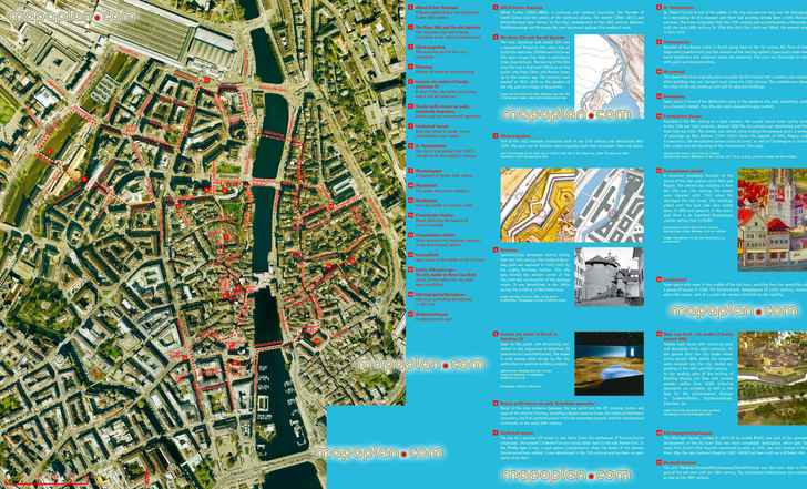
Download the free virtual explorer plan showing city map of Zurich, Switzerland - Walking tour guide itinerary planner showing layout of best things to do, city-break historical places to visit - Visitor's detailed virtual printable guide to download - Old town & inner city center walking tour guide itinerary planner map with favourite attractions & points of interest to visit by tourists - Zurich top tourist attractions map
You can view, download or print a full, high resolution (detailed, large) version of this image by clicking on the plan itself
Map of top 10 attractions in Zurich
The typical top ten attractions are listed below. You can find the detailed locations of these places on the maps above.
- Lake Zurich (Zurichsee) - This beautiful glacial lake stretches in a 40-km (25-mile) arc from Zurich to the foot of the Glarner Alps. The many boat trips departing from Zurich range from short trips to cruises of half a day, taking in several lakeshore towns and villages. The main landing stage in Zurich is at Burkliplatz. Being unpolluted, the lake's clear waters are also safe for swimming.
- Old Town (Altstadt) - Situated on both sides of the Limmat River, Altstadt (Old Town) is known for its squares, narrow cobblestone streets, and winding alleys. There are fountains, medieval houses, art galleries, boutiques, quaint restaurants, hotels (many moderately priced), and antiques shops.
- Fine Arts Museum (Kunsthaus Zurich) - One of the most important art museums in Europe, and Switzerland's greatest art gallery, the Kunsthaus contains important works of art ranging from medieval religious paintings and Dutch Old Masters to Impressionist and Post-Impressionist paintings.
- Bahnhofstrasse - Running north to south from Bahnhofplatz to the edge of the Zurichsee, Bahnhofstrasse is a long avenue that is located on the course of the medieval city's moat. Mostly pedestrianized, and with trams running along it, Bahnhofstrasse is Zurich's main shopping street and the centre of its commercial activity. It is lined with upmarket shops and popular restaurants, as well as the headquarters of several major Swiss banks. At the junction with Sihlstrasse and Seidengasse is Jelmoli, Zurich's foremost department store. Nearby there is a famous Clock Museum (Uhrenmuseum Beyer).
- Limmat Riverside (Limmatquai) - This attractive riverside boulevard runs along the east bank of the Limmat, from Bellevueplatz in the south to the Bahnhofbrucke in the north. The most interesting stretch of Limmatquai is its southern section, in the vicinity of the Grossmunster and Rathaus. Here the boulevard is lined with guild houses, which have been converted into shops or restaurants.
- Lindenhof and Lindenhof Square (Lindenhofplatz) - A tree-covered hill rises on the west bank of the Limmat. Although no buildings survive, an observation platform offers a view of the surrounding rooftops and of the university buildings to the east.
- Main Train Station (Hauptbahnhof) and Bahnhofplatz - Zurich's monumental Neo- Renaissance train station is one of the city's greatest icons. It is located at the beginning of Bahnhofstrasse.
- Grossmunster Church / Cathedral - The tall twin towers of the Grossmunster, or Great Minster, dominate Zurich's skyline from the east bank of the Limmat.
- Munsterhof - This square, on the left bank, is near such landmarks as Fraumunster and the Town Hall (Rathaus). You can reach it by walking along Schlusselgasse.
- Church of Our Lady (Fraumunster) - This church, with its slender, blue spire, is on the left bank overlooking the former pig market, Munsterhof. It is renowned for its distinctive stained-glass windows, designed by the Russian-Jewish master Marc Chagall.
- Niederdorf - Consisting of a dense network of cobbled alleys leading towards Limmatquai, the district of Niederdorf constitutes the heart of the Old Town's eastern section. The main artery through this historic district is Niederdorfstrasse, a pedestrianized thoroughfare that is continued by Munstergasse to the south. Niederdorf's narrow alleys are lined with antique shops and art galleries, as well as small hotels, cafes, restaurants, beer halls and fast-food outlets.
- Paradeplatz - This is the hub of Zurich and the central tram interchange. In the 18th century, it was a cattle market. The square is dominated by the 1876 mansion of Crédit Suisse.
- Burkliplatz - On the shore of Lake Zurich, this is the point where the Limmat River empties into the lake. This square overlooks Quaibrucke, a bridge across the Limmat that connects the left bank with the right bank. After stopping to admire the lake, you might also consider a boat excursion if it's summer.
- Bellevueplatz - Here you can enjoy the view of the lake and river as you rest on a park bench and watch all of Zurich pass by.
- Weinplatz - The site of the Corn Exchange until 1620, this is presumably the oldest market square in Zurich.
- Other attractions on our maps include: Uetliberg Mountain, Swiss National Museum (Schweizerisches Landesmuseum), Museum of Design (Museum fur Gestaltung); Migros Museum of Contemporary Art (Migros Museum fur Gegenwartskunst), Rietberg Museum, St. Peter's Church (St. Peterskirche), Botanical Garden (Botanischer Garten), Opera House (Opernhaus Zurich), Bellevue Square (Bellevueplatz), Buerkli Square Market (Buerkliplatz Markt), Augustinian Church (Augustinerkirche), Guild House (Zunfthaus zur Meisen), Women's Minster (Fraumunster), Water Church (Wasserkirche), University (Universitat), Federal Institute of Technology (ETH, Eidenössische Technische Hochschule), Zurichhorn Park, Zoological Garden Zoo (Zoologischer Garten).
What are some interesting facts about Zurich?
Orientation - Zurich lies situated on both shores of the Limmat River, which flows from the northern end of Lake Zurich. The Sihl River, a tributary of the Limmat, also flows through the city, and quays line the riverbanks and the lake. The city spreads across a ravine in the eastern hills between the wooded slopes of the Zurichberg and Kääferberg hills into the Glatt River valley. The hamlet that became Zurich began at the Lindenhof, which is where you, too, might begin your orientation to the city. This square is the architectural center of historic Zurich. From here, you can survey the city as it rises on both banks of the Limmat from Bahnhofbrucke (brucke means bridge) to Quailbrucke. Below this square runs Bahnhofstrasse, one of the most elegant and expensive shopping streets in the world. It begins in the north, at the Hauptbahnhof, the railway station, opening onto Bahnhofplatz, and runs south to the lake. It crosses Paradeplatz, a converging point for trams and the modern center of the city. From Paradeplatz you can continue east, passing Fraumunster church and crossing Munsterbrucke to reach the right bank of the river. Here, the narrow streets of the Limmatquai are the second-best place in the city to shop. Running parallel to Limmatquai is Niederdorfstrasse, in the so-called red-light district of Zurich. Old Town, or Altstadt, was developed during the early medieval period and is focused on Lindenhof, Fraumunster, Grossmunster, and St. Peter's. It expanded to Weinplatz, the oldest market square, and Strehlgasse. By the 11th century, the city continued its development on the right bank with such centers as Kirchgasse and Neumarkt.
Neighbourhoods and city layout - Zurich is divided by the Limmat River into the two general areas West (Left Bank) an East (Right Bank). West or Left Bank This district is dominated by Bahnhofplatz, center of rail connections, and Bahnhofstrasse, which is the main commercial and banking thoroughfare. This is the Zurich world of high finance and elegant shops. The venerable Fraumunster church, on Fraumunsterstrasse, dominates the west bank. East or Right Bank Opposite Fraumunster, on the other side of the river, rises Grossmunster church, on Grossmunsterplatz; its two Gothic towers are an east-bank landmark. The historic guildhalls of Zurich, such as the Zunfthaus zur Saffran, rise on the east bank of the river. So, too, does the Rathaus, the city's town hall, completed in 1698. On the east bank you can explore the eastern part of Altstadt, strolling along Neumarkt, one of the best preserved of the old streets. The area beyond is Niederdorf, the center of the town's 'hot spots.'
Getting around - Zurich and its quays are ideal for walking, and many of the places of interest, such as the sights of Altstadt on both sides of the Limmat, are conveniently grouped together.
Public transport - The public transport system of Zurich is operated by VBZ (Verkehrsbetriebe Zurich - Zurich Public Transport) and ZVV (Zurcher Verkehrsverbund - Zurich Transport Network). It consists of modern and extensive network of trams, buses and integrated S-Bahn suburban trains (there is no subway / metro / underground / tube). Most trams and buses connect at the Zurich Hauptbahnhof, in the heart of the city.
Tourist Information Centre - The Zurich Tourist Office is in Bahnhofplatz in the main railway station. Here you can find free pocket-size Stadtplan (city plan).
How can I find specific tourist attractions on the map of Zurich?
Our interactive city maps are easy to explore. You can pan, zoom in, and zoom out on the high-resolution map to locate major tourist attractions. Each map highlights key landmarks, making it simple to find the sights you're most interested in, whether it's a famous monument, museum, or other point of interest.
Can I get a visual representation of the area around Zurich?
For some cities, we provide a general view of the area surrounding popular attractions. While this image won't show the exact street-level view, it helps you understand the layout of the neighborhood, showing how the landmarks are situated in relation to other points of interest around Zurich.
Can I explore maps for both tourist attractions and other points of interest?
Yes! Our platform offers maps covering a range of highlights, from top tourist attractions to other noteworthy areas such as parks, restaurants, and entertainment venues. Whether you're planning a visit to a museum or looking for a nearby park, our detailed maps make it easy to find the best spots in the city.
Related keywords
2023, 2024, 2025, 2025, 2026, 2027, 2028, 2029, map, plan, download, print, printable, free, detailed, aerial, bird's eye, satellite, guide, planner, travel, sightseeing, visit, trip, tour, tourist, what to do, where to go, things to do, must see, top attractions, points of interest, places, sites, sights, buildings, spots, destinations, locations, landmark, museum, in a week, in 3 days, one day, city, route, bus, kids, children, top 10, top ten, popular, famous, interesting, highlights, public transport, rail, hotels, updated, metro, subway, underground, tube, downtown, coach, nightlife, pub, monument, satellite, accommodation, transit, transportation, supermarket, children, metro, subway, underground, tube